|
 Surveying caves is hard yakka. Sometimes it feels like surveying caves is to exploration, what cleaning up the day after is to hosting a party. This sentiment seems to be even stronger when having to survey underwater caves. Yet surveying caves is a necessary evil - it is the price you pay for exploration. Surveying caves is hard yakka. Sometimes it feels like surveying caves is to exploration, what cleaning up the day after is to hosting a party. This sentiment seems to be even stronger when having to survey underwater caves. Yet surveying caves is a necessary evil - it is the price you pay for exploration.
It is easy enough to do a rough and dirty line map that shows the general trend and dimensions of the cave - I must admit I am quite fond of the stick map myself. If the vis is decent you can grab the basic measurements like depth, distance, and azimuth pretty quickly as you exit the cave and then call it a day. But to actually produce a really nice and accurate representation of what is down there, to actually draw up a proper map is no easy feat.
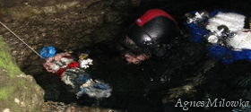
I was reminded of the frustrations of surveying the other day as I tried to survey a line in a tight passage and get all the measurements including the wall profiles. The silt rained down on me, quickly reducing the vis to zero and there I was trying to do a juggling act with the compass, the wet notes and a light and desperately trying to get some accurate data. Calling the experience frustrating is an understatement and I doubt I'll ever receive any awards for my map making skills.
So why put oneself though all the drama that surveying caves involves? Well, there is little point of exploration if you do not bring something back… if you fail to bring back information about what you found and discovered. We explore caves so that we can figure out what is down there, if you do not bring back that information and data for all to see, the impact of your dive is precisely zero. Any explorer will tell you - if you haven't surveyed it, it's like you haven't done it!
Publishing a cave map is important for a whole variety of reasons and can be useful to scientists, developers, land managers and even fellow divers. Realistically most people will never get a chance to see the cave passage you have just found and explored, so an accurate map gives everyone 'up top' an indication of what is down there.
Communities that rely on karst water resources, like North Florida for example, have benefited greatly from understanding the relationship between water flow and cave systems. Understanding the hydrology of the area and the crucial role caves play, has meant that steps have been implemented to ensure that the Floridian aquifer receives the kind of protection it deserves.
Understanding the location of a cave system can be useful information for landowners and government when they are developing housing projects, building roads, choosing boundaries of national parks or deciding where to put the latest rubbish tip. It is impossible to protect something that you do not understand or even know exists. Once the precise location of a cave system is known and the exact location of a cave passages can be pinpointed in relation to surface features, there is a hope in hell that the site can be protected from wanton or accidental damage.
Surveying caves isn't just useful for scientific purposes; it can actually make the task of further exploration easier. Once a map is drawn up it is easy to see the trend of the cave, its relationships to surface features and most importantly whether possible connections to other caves in the area exist. During the push to connect Peacock Springs and Baptizing Spring for example, knowing the direction to take was crucial for success. Without a map, even a simple stick map, we would have been stumbling around in there to this day looking for the way forward.
Then off course there is the warm fuzzy feeling you get when other cave divers use your map to plan their dives and gain an understanding of the cave before they venture inside it. At a minimum this helps other divers enjoy the cave fully and sometimes it may even save lives, as a map allows divers to picture the system as a whole and visualize their position in the underground maze.
So if you want to go exploring, knot your line, get your compass ready and make sure you survey the cave passages that you discover - no excuses. Even if the going is tough, even if your map is not a work of art, an accurate stick map is still better than nothing... and boy, am I thankful for that.
|
